
CIVE 201 Final Sample with Solutions, Spring 2015
American University of Beirut · Engineering Drawings & Tools · 2 pages · Dr. Ibrahim Alameddine · with solution
More CIVE 201 files
- Homework First Homework · Spring 2015HomeworkView
- Lecture Creating Data In GIS · Spring 2015LabView
- Lecture GIS 2 · Spring 2015LabView
- Lecture GIS 3 · Spring 2015LabView
- Lecture GIS 4 · Spring 2015LabView
- Lecture GIS 5 · Spring 2015LabView
- Lecture Revit Fifth Lecture · Spring 2015LabView
- Lecture Revit First Lecture · Spring 2015LabView
Show the text of this final exam
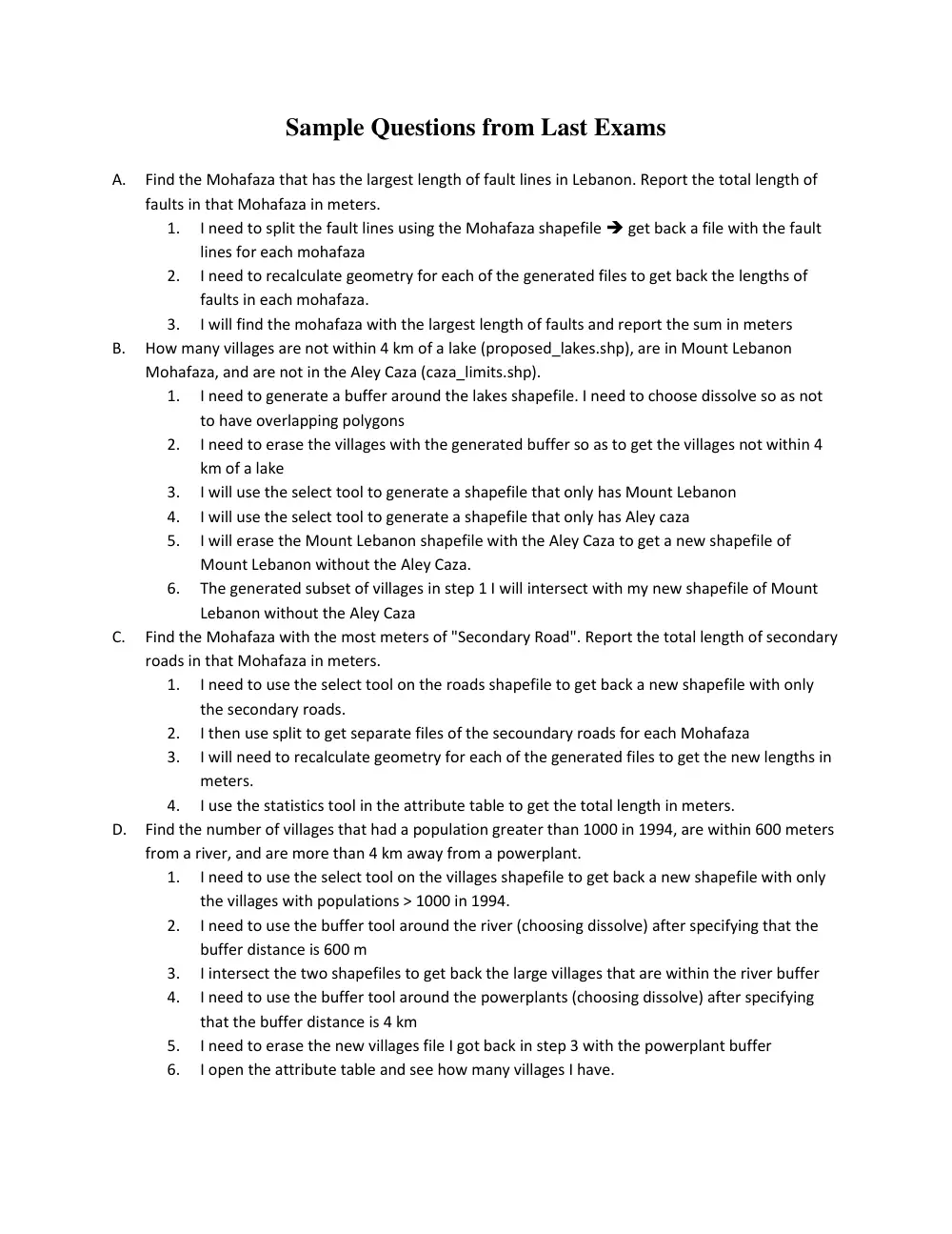
Sample Questions from Last Exams
A.
Find the Mohafaza that has the largest length of fault lines in Lebanon. Report the total length of
faults in that Mohafaza in meters.
1.
I need to split the fault lines using the Mohafaza shapefile get back a file with the fault
lines for each mohafaza
2.
I need to recalculate geometry for each of the generated files to get back the lengths of
faults in each mohafaza.
3.
I will find the mohafaza with the largest length of faults and report the sum in meters
B.
How many villages are not within 4 km of a lake (proposed_lakes.shp), are in Mount Lebanon
Mohafaza, and are not in the Aley Caza (caza_limits.shp).
1.
I need to generate a buffer around the lakes shapefile. I need to choose dissolve so as not
to have overlapping polygons
2.
I need to erase the villages with the generated buffer so as to get the villages not within 4
km of a lake
3.
I will use the select tool to generate a shapefile that only has Mount Lebanon
4.
I will use the select tool to generate a shapefile that only has Aley caza
5.
I will erase the Mount Lebanon shapefile with the Aley Caza to get a new shapefile of
Mount Lebanon without the Aley Caza.
6.
The generated subset of villages in step 1 I will intersect with my new shapefile of Mount
Lebanon without the Aley Caza
C.
Find the Mohafaza with the most meters of "Secondary Road". Report the total length of secondary
roads in that Mohafaza in meters.
1.
I need to use the select tool on the roads shapefile to get back a new shapefile with only
the secondary roads.
2.
I then use split to get separate files of the secoundary roads for each Mohafaza
3.
I will need to recalculate geometry for each of the generated files to get the new lengths in
meters.
4.
I use the statistics tool in the attribute table to get the total length in meters.
D. Find the number of villages that had a population greater than 1000 in 1994, are within 600 meters
from a river, and are more than 4 km away from a powerplant.
1.
I need to use the select tool on the villages shapefile to get back a new shapefile with only
the villages with populations > 1000 in 1994.
2.
I need to use the buffer tool around the river (choosing dissolve) after specifying that the
buffer distance is 600 m
3.
I intersect the two shapefiles to get back the large villages that are within the river buffer
4.
I need to use the buffer tool around the powerplants (choosing dissolve) after specifying
that the buffer distance is 4 km
5.
I need to erase the new villages file I got back in step 3 with the powerplant buffer
6.
I open the attribute table and see how many villages I have.
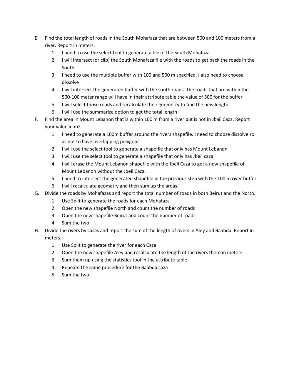
E.
Find the total length of roads in the South Mohafaza that are between 500 and 100 meters from a
river. Report in meters.
1.
I need to use the select tool to generate a file of the South Mohafaza
2.
I will intersect (or clip) the South Mohafaza file with the roads to get back the roads in the
South
3.
I need to use the multiple buffer with 100 and 500 m specified. I also need to choose
dissolve
4.
I will intersect the generated buffer with the south roads. The roads that are within the
500-100 meter range will have in their attribute table the value of 500 for the buffer
5.
I will select those roads and recalculate their geometry to find the new length
6.
I will use the summarize option to get the total length
F.
Find the area in Mount Lebanon that is within 100 m from a river but is not in Jbail Caza. Report
your value in m2.
1.
I need to generate a 100m buffer around the rivers shapefile. I need to choose dissolve so
as not to have overlapping polygons
2.
I will use the select tool to generate a shapefile that only has Mount Lebanon
3.
I will use the select tool to generate a shapefile that only has Jbeil caza
4.
I will erase the Mount Lebanon shapefile with the Jbeil Caza to get a new shapefile of
Mount Lebanon without the Jbeil Caza.
5.
I need to intersect the generated shapefile in the previous step with the 100 m river buffer
6.
I will recalculate geometry and then sum up the areas.
G. Divide the roads by Mohafazas and report the total number of roads in both Beirut and the North.
1.
Use Split to generate the roads for each Mohafaza
2.
Open the new shapefile North and count the number of roads
3.
Open the new shapefile Beirut and count the number of roads
4.
Sum the two
H. Divide the rivers by casas and report the sum of the length of rivers in Aley and Baabda. Report in
meters.
1.
Use Split to generate the river for each Caza
2.
Open the new shapefile Aley and recalculate the length of the rivers there in meters
3.
Sum them up using the statistics tool in the attribute table
4.
Repeate the same procedure for the Baabda caza
5.
Sum the two