
GEOL 203 Final, Spring 2008
American University of Beirut · Physical Geology Laboratory · 7 pages

Show the text of this final exam
Geology 203: Final Exam
Time allowed: 2 hours
Exam rules apply
Section A (50 marks)
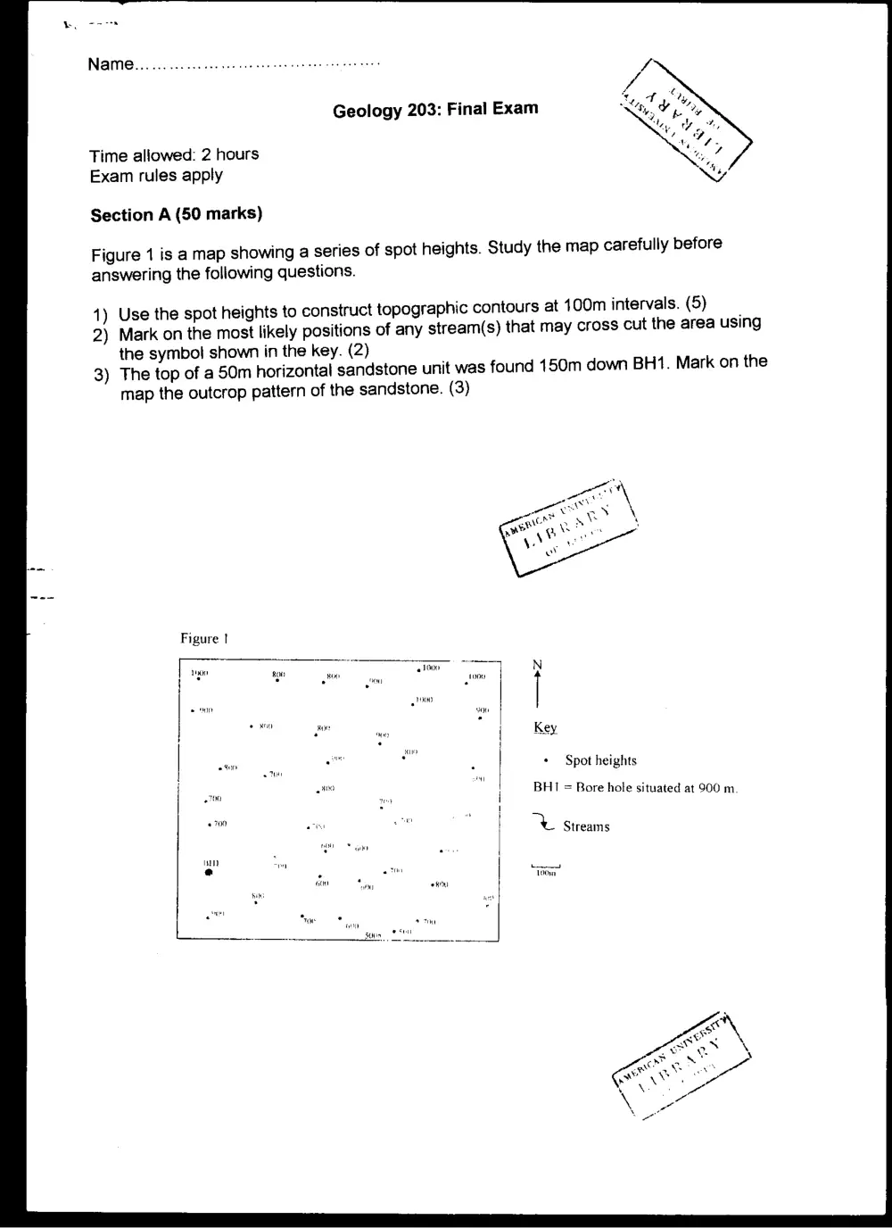
Figure 1 is a map showing a series of spot heights. Study the map carefully before
answering the following questions.
1) Use the spot heights to construct topographic contours at 100m intervals. (5)
2) Mark on the most likely positions of any stream(s) that may cross cut the area using
the symbol shown in the key. (2)
3) The top of a 50m horizontal sandstone unit was found 150m down BH1. Mark on the
map the outcrop pattern of the sandstone. (3)
21000
t900
100
90
+ Spot heights
BHI = Bore hole situated at 900 m.
no Streams
foooenn)
100m
Name...... occ cc cece ee eee en eee ce eee tees
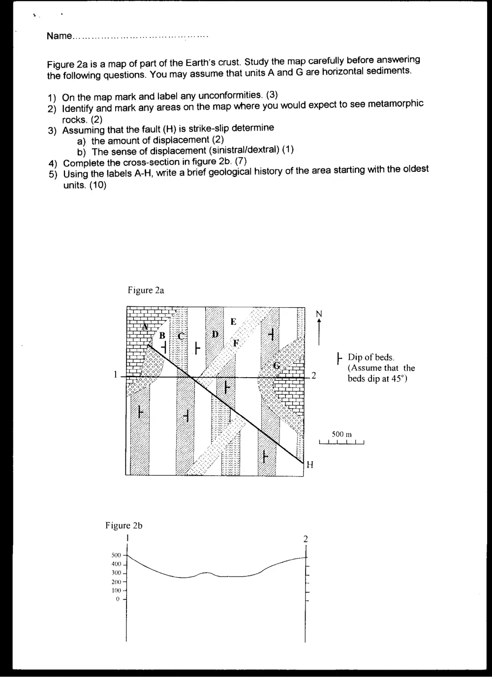
Figure 2a is a map of part of the Earth’s crust. Study the map carefully before answering
the following questions. You may assume that units A and G are horizontal sediments.
1) On the map mark and label any unconformities. (3)
2) Identify and mark any areas on the map where you would expect to see metamorphic
rocks. (2)
3) Assuming that the fault (H) is strike-slip determine
a) the amount of displacement (2)
b) The sense of displacement (sinistral/dextral) (1)
4) Complete the cross-section in figure 2b. (7)
5) Using the labels A-H, write a brief geological history of the area starting with the oldest
units. (10)
Figure 2a
f Dip of beds.
(Assume that the
beds dip at 45°)
Figure 2b
|
Me
500 4
Name... o.oo cece cece cee ener eee te ners
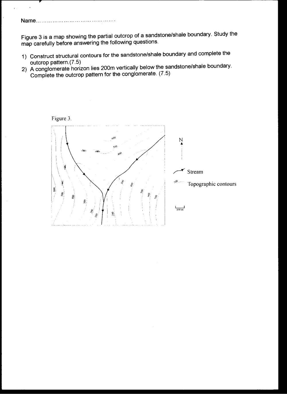
Figure 3 is a map showing the partial outcrop of a sandstone/shale boundary. Study the
map carefully before answering the following questions.
1) Construct structural contours for the sandstone/shale boundary and complete the
outcrop pattern.(7.5)
2) Aconglomerate horizon lies 200m vertically below the sandstone/shale boundary.
Complete the outcrop pattern for the conglomerate. (7.5)
Figure 3.
Topographic contours
100 nr
Name... 00... cece cee cee eee ete eee eee eee
Section B (25 marks)
1) Define scale with respect to airphotos. Give the formula for determining the scale and
draw the appropriate scheme. (8)
2) Give a comparison of the scale of hills and valleys as seen on airphotos. Which scale
is larger, give reasons. Draw a scheme to show this. (8)
3) Describe how aerial photographs are taken. (9)
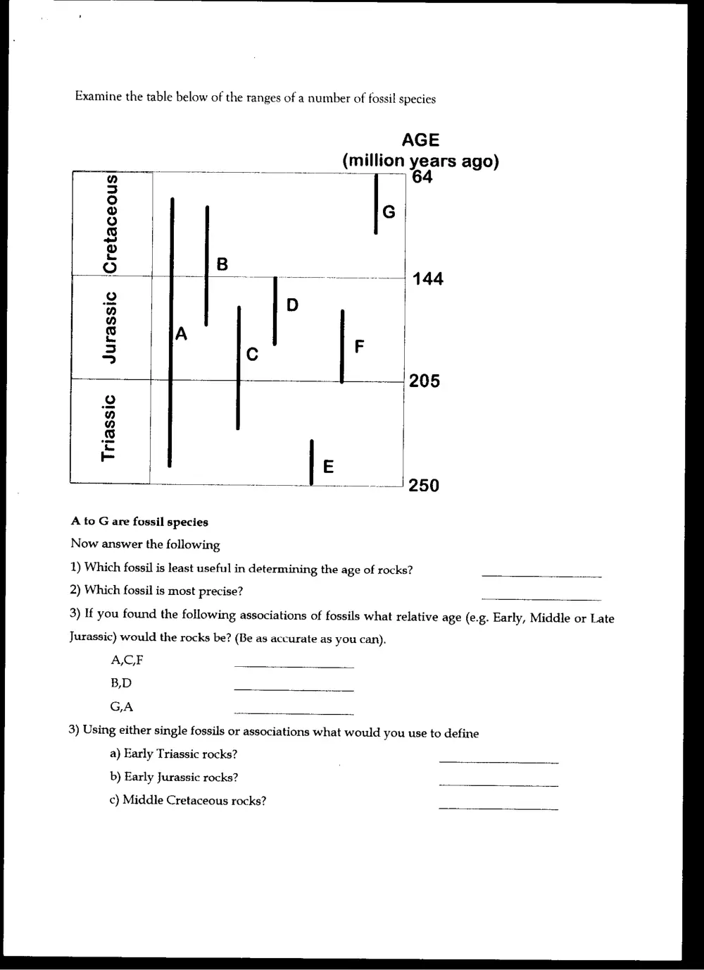
Examine the table below of the ranges of a number of fossil species
AGE
(million years ago)
7 64
‘Cretaceous
Jurassic
Triassic
A to G are fossil species
Now answer the following
1) Which fossil is least useful in determining the age of rocks?
2) Which fossil is most precise?
3) If you found the following associations of fossils what relative age (e.g. Early, Middle or Late
Jurassic) would the rocks be? (Be as accurate as you can).
ACF
B,D
GA
3) Using either single fossils or associations what would you use to define
a) Early Triassic rocks?
b) Early Jurassic rocks?
c) Middle Cretaceous rocks?
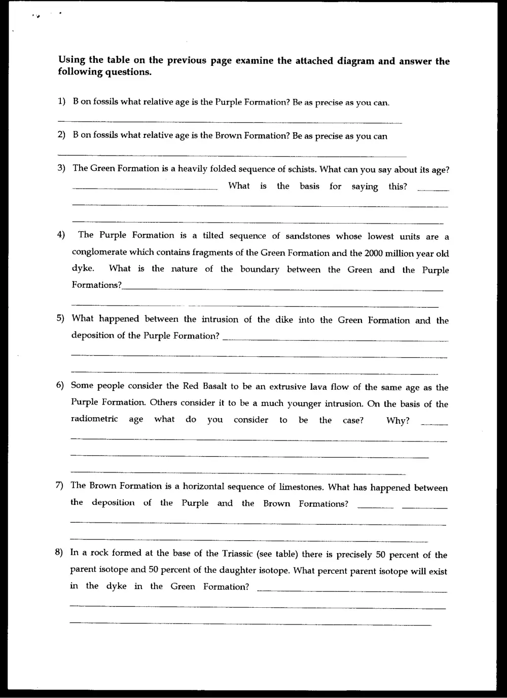
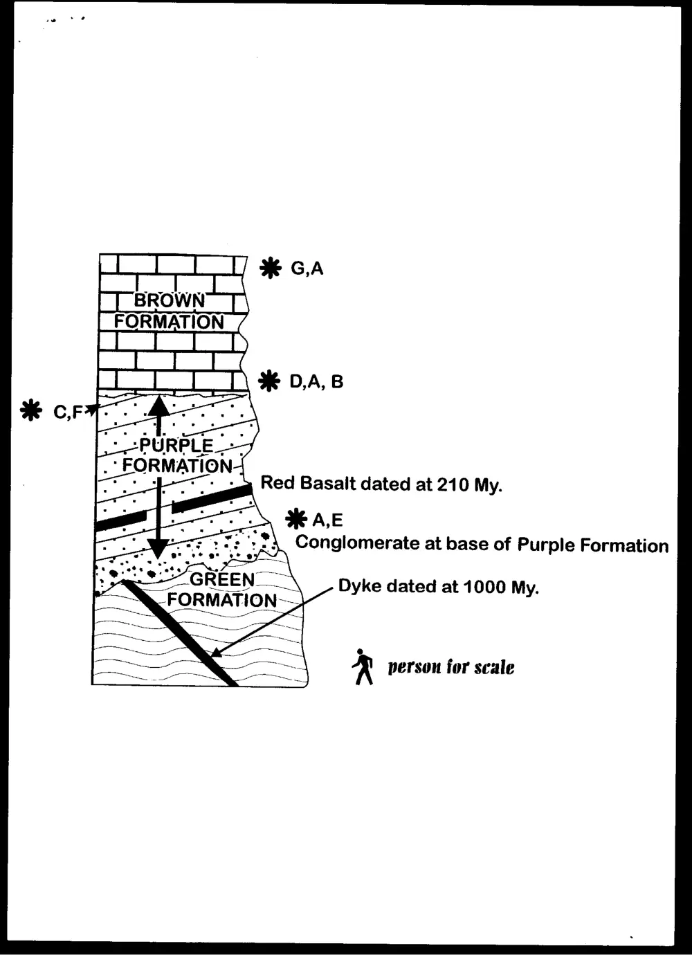
Using the table on the previous page examine the attached diagram and answer the
following questions.
0)
B on fossils what relative age is the Purple Formation? Be as precise as you can.
2)
B on fossils what relative age is the Brown Formation? Be as precise as you can
The Green Formation is a heavily folded sequence of schists. What can you say about its age?
What is the basis for saying this?
The Purple Formation is a tilted sequence of sandstones whose lowest units are a
conglomerate which contains fragments of the Green Formation and the 2000 million year old
dyke. What is the nature of the boundary between the Green and the Purple
Formations?
What happened between the intrusion of the dike into the Green Formation and the
deposition of the Purple Formation?
Some people consider the Red Basalt to be an extrusive lava flow of the same age as the
Purple Formation. Others consider it to be a much younger intrusion. On the basis of the
radiometric age what do you consider to be the case? Why?
The Brown Formation is a horizontal sequence of limestones. What has happened between
the deposition of the Purple and the Brown Formations?
In a rock formed at the base of the Triassic (see table) there is precisely 50 percent of the
parent isotope and 50 percent of the daughter isotope. What percent parent isotope will exist
in the dyke in the Green Formation?
Red Basalt dated at 210 My.
Ln HEA,E
Ft Te": *} Conglomerate at base of Purple Formation
. hte thy A
Dyke dated at 1000 My.
e
K person for scale