
GEOL 304 Final, Spring 1997
American University of Beirut · Geophysics I · 5 pages


Show the text of this final exam
American University of Beirut
Geology 304
Final Exam
Student Name: June 20, 1997
Part I. Circle T = true and F= false and explain why if it is false (40 pts.).
TF 1. Migration is the process that repositions reflected energy from its CMP
position to its true subsurface location.
TF 2. Due to the filtering action of the earth which causes time lags, it is easier to
determine the absolute depth of a reflecting interface than to measure
relative depths between two points located at the same reflecting boundary.
. Diffraction patterns originate from the edges of beds disrupted by faulting or
basement irregularities...etc. The resulting pattern will have shape like trace
of maximum convexity. sometimes they may look deceptively like a
reflection of symmetrical syncline.
. The velocity pitfalls in structural interpretation of seismic data, occur when
the velocity of a certain body is more than that in the surrounding (laterally),
this would reflect a structural uplift below this body.
TF 5. A reflection does not originate from a point on a reflector but from a zone
on the reflector. The radial width of this zone (The Fresnel zone) is defined
as
V it
FE,
"AVF
F 6. P waves are affected by the gas saturation in the pore space and travel at
slower velocity, while shear waves travel at higher velocity.
F 7. The interference effects on reflection amplitudes might occur when two or
more reflecting surfaces are close together compared to wavelength. The
pulses reflected will be superimposed and the amplitude will always be
stronger. R
Dr. K. Khair Geology 304 (Final Exam)
F 8. The natural frequency of geophones used in refraction prospecting is
normally higher than that of the geophones used in ordinary reflection
prospecting.
F 9. In refraction method, only the initial arrivals of seismic energy (first and
second events) are recorded.
F 10. If any bed in the sequence has a lower speed than the one above, it will not
be detectable by refraction shooting at all.
F 11. In land areas, the geoid is defined as the surface that would be assumed by
the top of the water in a narrow sea level canal extended inland across
continents connecting one ocean to another,
F 12. The gravitational potential is defined as the work required for gravity to
move one unit mass from infinite distance to the point in question (at
distance R).
F 13. Pratt's hypothesis of Isostasy suggests that the crust has uniform density
and laterally varying roots.
F 14. The regions with negative isostatic anomaly (areas covered by ice during
Pleistocene) are isostatically undercompensated.
F 15. The drift of gravimeters is caused by earth tides and uncompensated
temperature effects.
F 16. The Bouguer correction accounts for the attraction of the slab of material
having a bottom surface at sea level and a top surface at the elevation of the
station.
Geology 304 (Final Exam)
Part I. Answer the following three questions (30 pts).
1. Transmission of refracted waves:
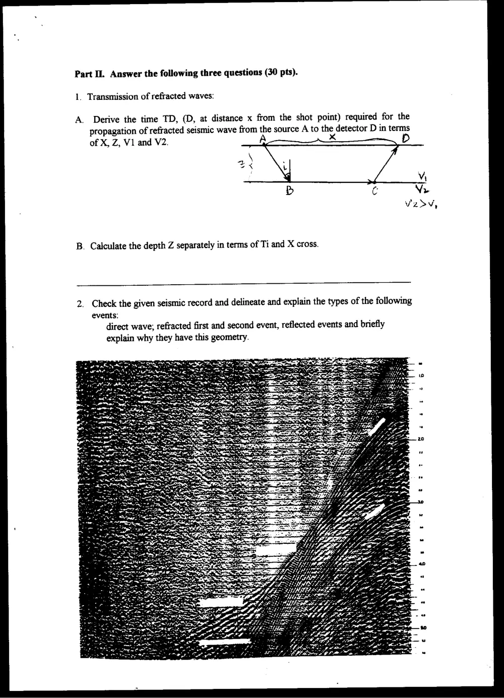
A. Derive the time TD, (D, at distance x from the shot point) required for the
propagation of refracted seismic wave from the source A to the detector D in terms
of X, Z, V1 and V2. A x D
\
t
%
B. Calculate the depth Z separately in terms of Ti and X cross.
2. Check the given seismic record and delineate and explain the types of the following
events:
direct wave; refracted first and second event, reflected events and briefly
explain why they have this geometry.
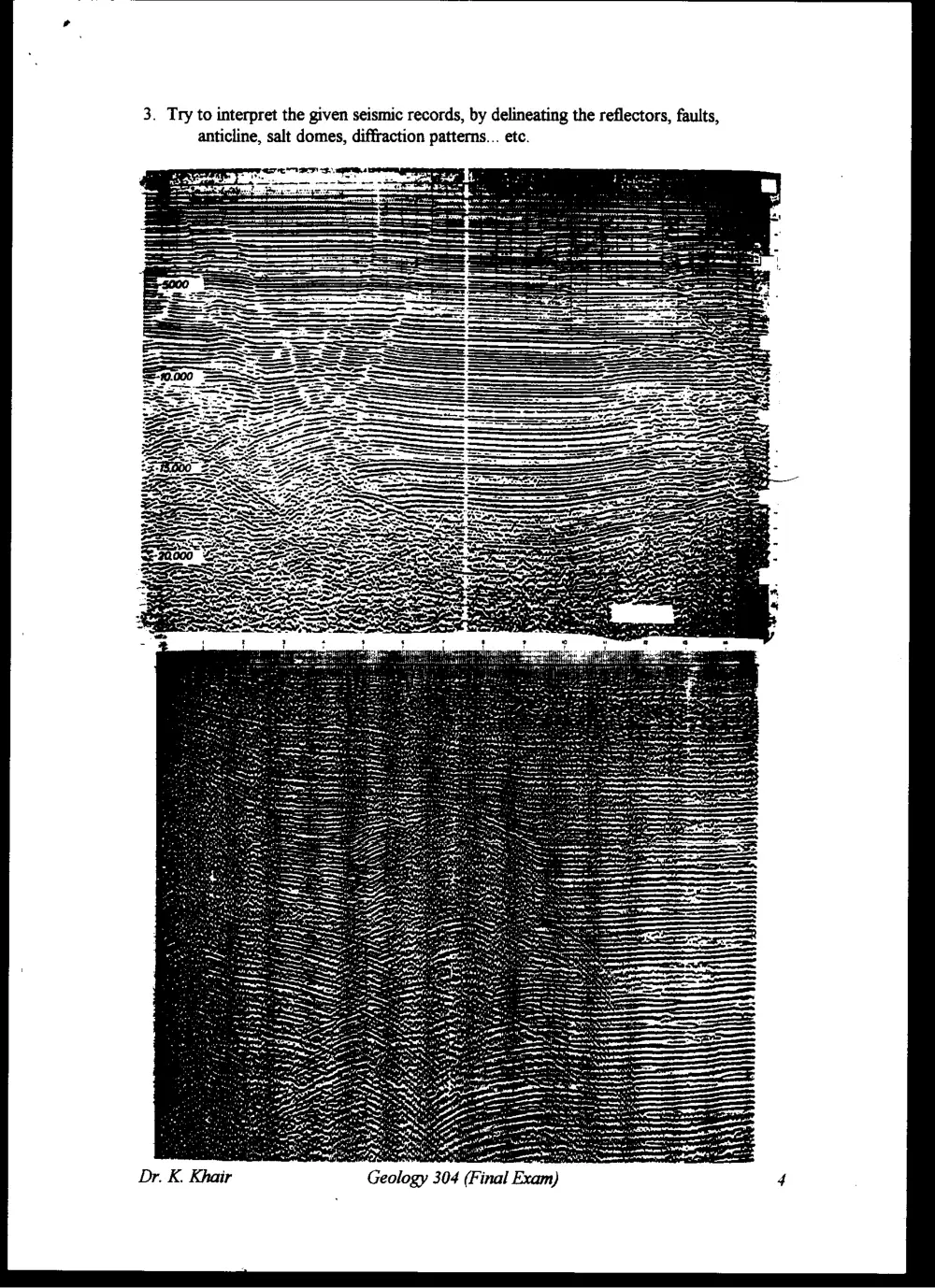
3. Try to interpret the given seismic records, by delineating the reflectors, faults,
anticline, salt domes, diffraction patterns... etc.
rm
\
{
Part IML Answer three of the following four questions (30pts.)
1. Discuss the case of blind zone (refraction shooting) and draw illustrative cross-
section and time-distance diagram.
2. Discuss the global variation in gravity, the reason behind it, and indicate and define
the theoretical and real shape of the earth's globe.
3. Discuss the free air, latitude and terrain corrections (draw schemes).
4. Discuss the gravity measurement on land including determining position for
stations, surveying; transportation and operation of the instrument, and adjustment
for drift.
GOOD LUCK
Geology 304 (Final Exam)