
GEOL 102 Final, Fall 2005
American University of Beirut · Environmental Physical Geography · 9 pages

More GEOL 102 files
- Final Previous · Fall 2003Final examView
- Final · Spring 2000Final examView
- Final · Fall 1999Final examView
- Final · Spring 1999Final examView
- Problems Topic 6 · Spring 2012ProblemsView
- Exam 1 Previous with Answers · Fall 2003Exam · with solutionView
- Exam 1 Previous with Answers · Fall 2003Exam · with solutionView
- Exam 2 Previous · Fall 2003ExamView
Show the text of this final exam
AMERICAN UNIVERSITY OF BEIRUT
Department of Geology
Geo. 102 FINAL Exam
Date: 23/01/2006
Time: 2 hrs.
Part I: Multiple-choice questions (75%).
Choose the best answer for the following 50 questions.
1. Which sphere provides the platform for most life forms on Earth?
a. atmosphere
b. hydrosphere
c. lithosphere
d. biosphere
2. The second abundant gas in the atmosphere is:
a. oxygen
b. carbon dioxide
c. nitrogen
d. ozone
3. The Sun emits ____________, and the Earth emits __________ .
a. longwave radiation ; longwave radiation
b. shortwave radiation ; shortwave radiation
c. longwave radiation ; shortwave radiation
d. shortwave radiation ; longwave radiation
4. The planet closest to the Earth is:
a. Neptune
b. Saturn
c. Mercury
c. Venus
5. The cause of seasonality is:
a. parallelism
b. axis tilt
c. revolution
d. all of the above
6. The main driving force for winds is the:
a. Coriolis force
b. frictional force
c. pressure-gradient force
d. centrifugal force
Grade
100
2
7. A wind coming from the east to the west is called a/an:
a. westerly wind
b. easterly wind
c. northeasterly wind
d. northwesterly wind
8. The grid of the Earth is made up of:
a. east-west latitudes and north-south longitudes
b. east-west meridians and north south parallels
c. east-west longitudes and north-south latitudes
d. east-north latitudes and west-south longitudes
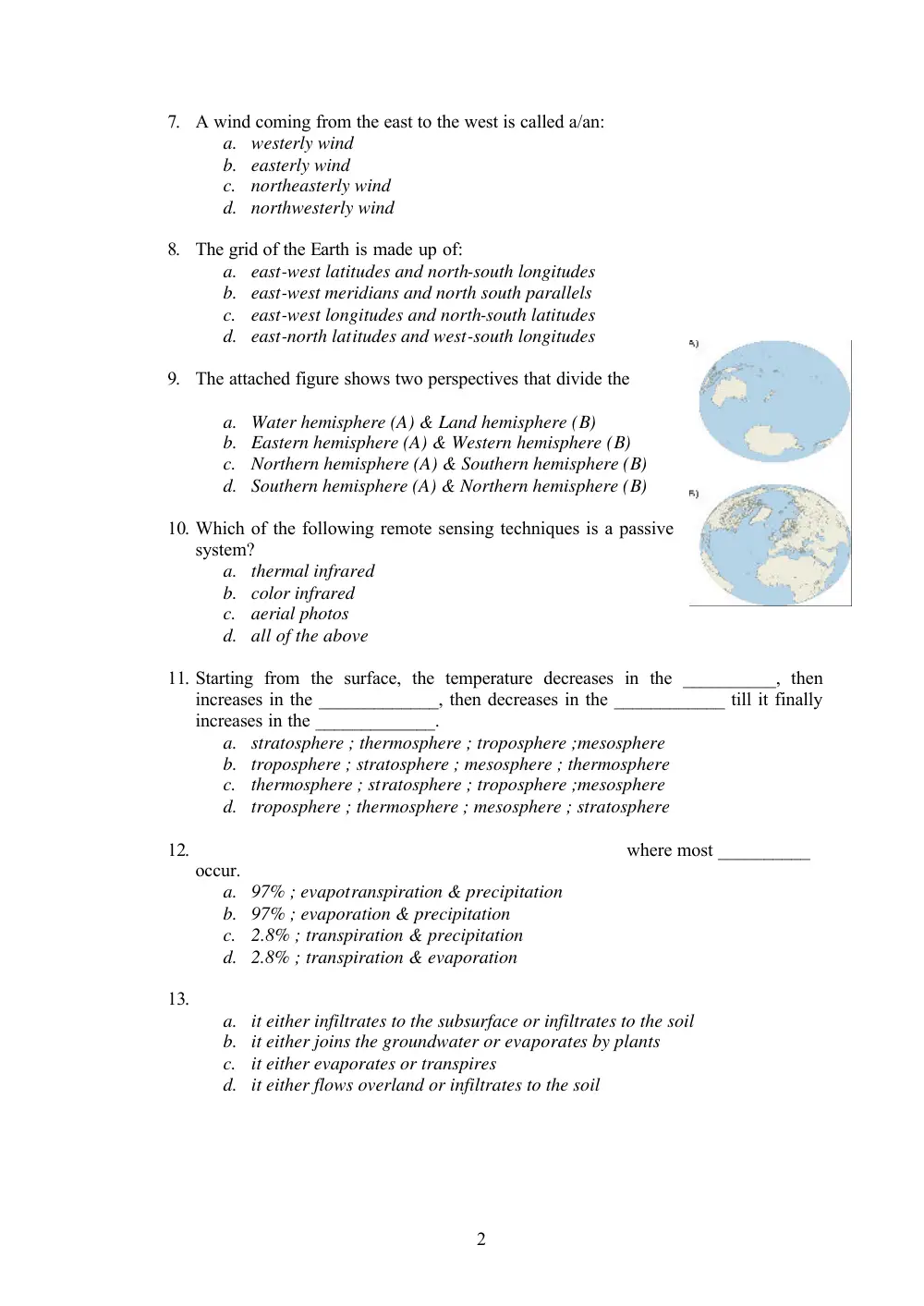
9. The attached figure shows two perspectives that divide the
a. Water hemisphere (A) & Land hemisphere (B)
b. Eastern hemisphere (A) & Western hemisphere (B)
c. Northern hemisphere (A) & Southern hemisphere (B)
d. Southern hemisphere (A) & Northern hemisphere (B)
10. Which of the following remote sensing techniques is a passive
system?
a. thermal infrared
b. color infrared
c. aerial photos
d. all of the above
11. Starting from the surface, the temperature decreases in the __________, then
increases in the _____________, then decreases in the ____________ till it finally
increases in the _____________.
a. stratosphere ; thermosphere ; troposphere ;mesosphere
b. troposphere ; stratosphere ; mesosphere ; thermosphere
c. thermosphere ; stratosphere ; troposphere ;mesosphere
d. troposphere ; thermosphere ; mesosphere ; stratosphere
12.
where most __________
occur.
a. 97% ; evapotranspiration & precipitation
b. 97% ; evaporation & precipitation
c. 2.8% ; transpiration & precipitation
d. 2.8% ; transpiration & evaporation
13.
a. it either infiltrates to the subsurface or infiltrates to the soil
b. it either joins the groundwater or evaporates by plants
c. it either evaporates or transpires
d. it either flows overland or infiltrates to the soil
3
14. According to the idealized model of surface atmospheric circulation,_________
broad pressure areas (features) exist the Northern hemisphere and a __________ set
exists in the Southern hemisphere of which one feature is in common.
a. 2 ; similar
b. 4 ; different
c. 2 ; different
d. 4 ; similar
15.
a. Coriolis force
b. density differences
c. frictional drag of winds
d. all of the above
16. The amount of solar insolation falling on the surface of the Earth depends mainly
on the:
a. angle of incidence
b. solar radiation output of the sun
c. amount of glacial coverage in a particular area
d. amount of ocean surface in a particular region
17. The circulation systems of surface ocean currents are known as ___________, and
they move ___________ in the Southern hemisphere.
a. highs ; clockwise
b. highs ; counterclockwise
c. gyres ; clockwise
d. gyres ; counterclockwise
18. The greatest amount of insolation reaching the Earth is at the:
a. the poles
b. the equatorial region
c. the midlatitudes
d. the subtropics
19. The air pressure surface zone located between about 10oN & 10oS is called the
____________, and it is caused by ____________ factors.
a. subtropical high ; dynamic
b. subtropical high ; thermal
c. equatorial low ; thermal
d. equatorial low ; dynamic
20. The Coriolis effect is:
a.
curve to the right in the Northern Hemisphere
b.
on from the west to the east and causes objects
to curve to the right in the Northern Hemisphere
c.
to curve to the left in the Northern Hemisphere
d. none
4
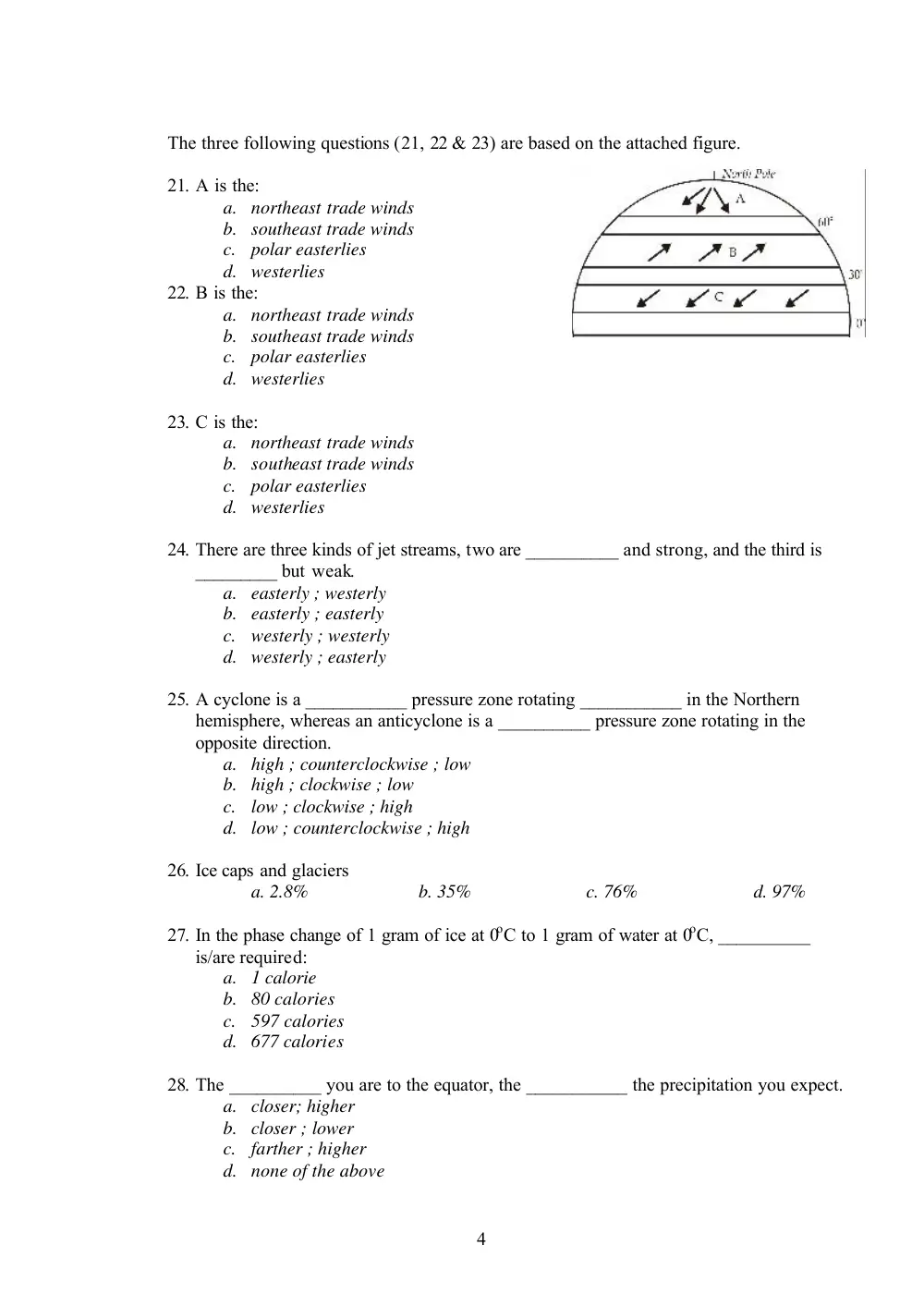
The three following questions (21, 22 & 23) are based on the attached figure.
21. A is the:
a. northeast trade winds
b. southeast trade winds
c. polar easterlies
d. westerlies
22. B is the:
a. northeast trade winds
b. southeast trade winds
c. polar easterlies
d. westerlies
23. C is the:
a. northeast trade winds
b. southeast trade winds
c. polar easterlies
d. westerlies
24. There are three kinds of jet streams, two are __________ and strong, and the third is
_________ but weak.
a. easterly ; westerly
b. easterly ; easterly
c. westerly ; westerly
d. westerly ; easterly
25. A cyclone is a ___________ pressure zone rotating ___________ in the Northern
hemisphere, whereas an anticyclone is a __________ pressure zone rotating in the
opposite direction.
a. high ; counterclockwise ; low
b. high ; clockwise ; low
c. low ; clockwise ; high
d. low ; counterclockwise ; high
26. Ice caps and glaciers
a. 2.8%
b. 35%
c. 76%
d. 97%
27. In the phase change of 1 gram of ice at 0oC to 1 gram of water at 0oC, __________
is/are required:
a. 1 calorie
b. 80 calories
c. 597 calories
d. 677 calories
28. The __________ you are to the equator, the ___________ the precipitation you expect.
a. closer; higher
b. closer ; lower
c. farther ; higher
d. none of the above
5
29. Evaporation of water from plants is called:
a. radiation
b. transpiration
c. evapotranspiration
d. evaporation
30. A parcel of air whose relative humidity is 10 % cools following the:
a. dry adiabatic lapse rate (DALR)
b. saturated adiabatic lapse rate (SALR)
c. environmental lapse rate (ELR)
d. none
31. The temperature at which air achieves saturation is called the:
a. sublimation temperature
b. condensation temperature
c. coalescence point
d. dew point
32.
a. ocean currents in the northern hemisphere
b. ocean currents in the southern ocean
c. wind flow patterns along the equatorial zone
d. ocean currents in the Atlantic Ocean
The four following questions (33, 34, 35 & 36) are related.
33. Air at 100 m altitude has a temperature of 20oC. It rises over a 2000 m mountain
before it descends into a basin with an elevation of 100 m. What is the lifting
condensation level? (given: dew point is 5oC)
a. 100 m
b. 500 m
c. 1500 m
d. 1600 m
34. Using the saturation curve,
what is the relative humidity
at 1100 m.
a. 0%
b. 43%
c. 71%
d. 100%
35. What is the relative humidity
at 1650 m?
a. 0%
b. 43%
c. 71%
d. 100%
6
36. What is the temperature in the basin on the leeward side of the mountain? (given:
SALR = 0.6oC/100m)
a. 20oC
b. 21oC
c. 21.6oC
d. 22.4oC
37. Clouds are visible masses made up of:
a. water vapor
b. water liquid droplets
c. water ice crystals
d. b or c
38. The heat involved in the change of water from the solid state to the liquid state is
called:
a. latent heat of fusion
b. latent heat of vaporization
c. latent heat of condensation
d. latent heat of melting
39. Mixing ratio:
a. is the total amount of water vapor present in the air
b. is the amount of water vapor in the air to the total mass of air
c. is the amount of water vapor in the air to the capacity
d. it is the amount of water vapor present in the air to the mass of dry air
40. Clouds are usually classified on the basis of __________ and __________.
a. altitude ; process of formation
b. color ; shape
c. altitude ; shape
d. altitude ; temperature
41. When a cold air mass moves in a warmer surrounding, it results in a/an:
a. warm front
b. cold front
c. stationary front
d. occluded front
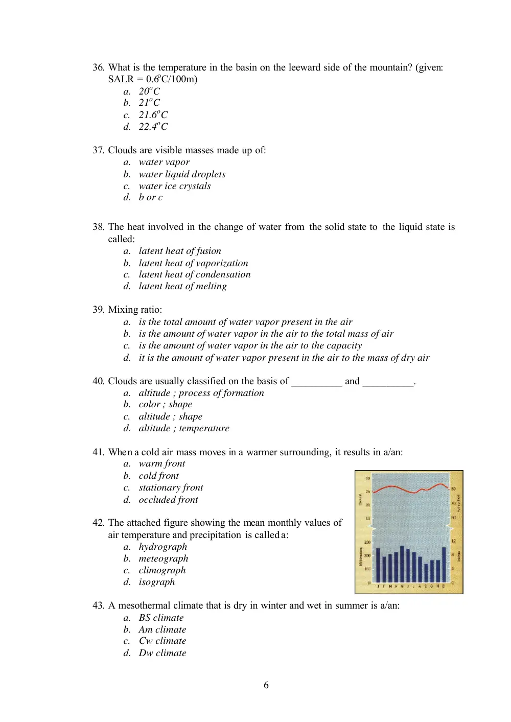
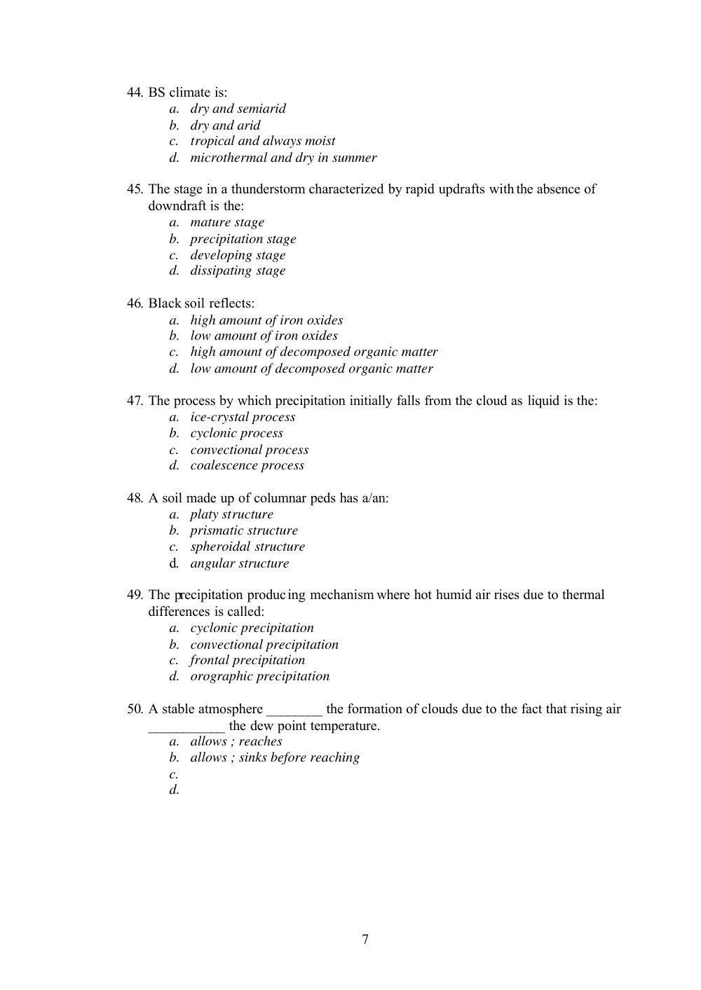
42. The attached figure showing the mean monthly values of
air temperature and precipitation is called a:
a. hydrograph
b. meteograph
c. climograph
d. isograph
43. A mesothermal climate that is dry in winter and wet in summer is a/an:
a. BS climate
b. Am climate
c. Cw climate
d. Dw climate
7
44. BS climate is:
a. dry and semiarid
b. dry and arid
c. tropical and always moist
d. microthermal and dry in summer
45. The stage in a thunderstorm characterized by rapid updrafts with the absence of
downdraft is the:
a. mature stage
b. precipitation stage
c. developing stage
d. dissipating stage
46. Black soil reflects:
a. high amount of iron oxides
b. low amount of iron oxides
c. high amount of decomposed organic matter
d. low amount of decomposed organic matter
47. The process by which precipitation initially falls from the cloud as liquid is the:
a. ice-crystal process
b. cyclonic process
c. convectional process
d. coalescence process
48. A soil made up of columnar peds has a/an:
a. platy structure
b. prismatic structure
c. spheroidal structure
d. angular structure
49. The precipitation producing mechanism where hot humid air rises due to thermal
differences is called:
a. cyclonic precipitation
b. convectional precipitation
c. frontal precipitation
d. orographic precipitation
50. A stable atmosphere ________ the formation of clouds due to the fact that rising air
___________ the dew point temperature.
a. allows ; reaches
b. allows ; sinks before reaching
c.
d.
8
Part II: (25%).
Answer two of the three following questions.
1. Compare and contrast between a tornado and a hurricane (write in a table format 3
similarities and 3 differences).
2. Answer the following based on the provided table:
a. Calculate the actual evapotranspiration for each month (fill in the table),
then calculate the annual value.
b. Calculate the annual precipitation.
c. Assuming that infiltration is 238 mm/year, then what is the expected annual
surface runoff?
Jan
Feb
Mar
Apr May Jun
Jul
Aug
Sep
Oct
Nov
Dec
PET1
25.78
29.37
41.20
57.60 77.51 94.59 109.73 109.79
90.46
67.44
42.90
29.41
Precipitation
190.09 133.40 110.80
46.30 15.00
1.50
0.30
0.40
2.30
54.80 105.90 163.80
Soil moisture
100.00 100.00 100.00
88.70 26.00
0.00
0.00
0.00
0.00
0.00
63.00
100.00
AET2
* Values are given in mm.
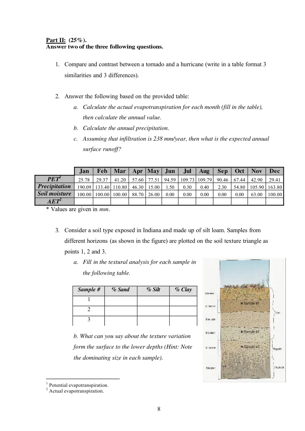
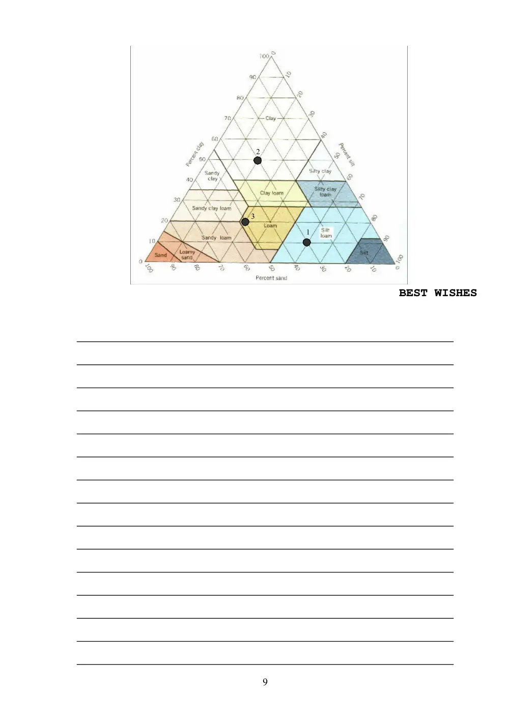
3. Consider a soil type exposed in Indiana and made up of silt loam. Samples from
different horizons (as shown in the figure) are plotted on the soil texture triangle as
points 1, 2 and 3.
a. Fill in the textural analysis for each sample in
the following table.
b. What can you say about the texture variation
form the surface to the lower depths (Hint: Note
the dominating size in each sample).
1 Potential evapotranspiration.
2 Actual evapotranspiration.
Sample #
% Sand
% Silt
% Clay
1
2
3
9
BEST WISHES
2
1
3