
GEOL 313 Final, Fall 1995
American University of Beirut · Photogeology · 9 pages



More GEOL 313 files
Show the text of this final exam
ene ee
os we Reading Room 3
Rese C 7 :
American University of Beirut
Geology 313
Final Exam
Student Name: February 5, 1996
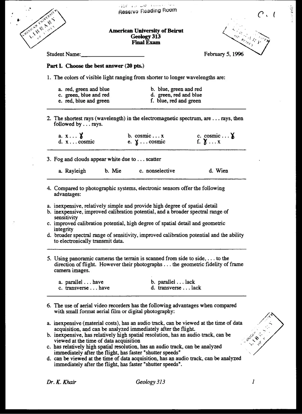
Part I. Choose the best answer (20 pts.)
1. The colors of visible light ranging from shorter to longer wavelengths are:
a. red, green and blue b. blue, green and red
c. green, blue and red d. green, red and blue
e. red, blue and green f. blue, red and green
2. The shortest rays (wavelength) in the electromagnetic spectrum, are . . . rays, then
followed by .. . rays.
aX. ¥ b. cosmic...x c. cosmic... X
d. x... cosmic e. ¥ ... cosmic £.¥...x
3. Fog and clouds appear white due to . . . scatter
a. Rayleigh b. Mie c. nonselective d. Wien
4, Compared to photographic systems, electronic sensors offer the following
advantages:
inexpensive, relatively simple and provide high degree of spatial detail
inexpensive, improved calibration potential, and a broader spectral range of
sensitivity
c. improved calibration potential, high degree of spatial detail and geometric
integrity
d. broader spectral range of sensitivity, improved calibration potential and the ability
to electronically transmit data.
oP
5. Using panoramic cameras the terrain is scanned from side to side, . . . to the
direction of flight. However their photographs . . . the geometric fidelity of frame
camera images.
a. parallel... have b. parallel ... lack
c. transverse ... have d. transverse ... lack
6. The use of aerial video recorders has the following advantages when compared
with small format aerial film or digital photography:
a. inexpensive (material costs), has an audio track, can be viewed at the time of data
acquisition, and can be analyzed immediately after the flight.
b. inexpensive, has relatively high spatial resolution, has an audio track, can be
viewed at the time of data acquisition
c. has relatively high spatial resolution, has an audio track, can be analyzed
immediately after the flight, has faster "shutter speeds"
d. can be viewed at the time of data acquisition, has an audio track, can be analyzed
immediately after the flight, has faster "shutter speeds".
Dr. K. Khair Geology 313 I
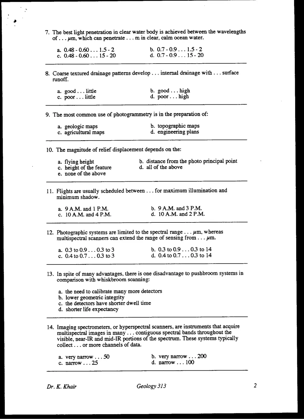
. The best light penetration in clear water body is achieved between the wavelengths
of... wm, which can penetrate . . . m in clear, calm ocean water.
a. 0.48 - 0.60...1.5-2 b. 0.7-0.9...1.5-2
c. 0.48 - 0.60... 15-20 d. 0.7-0.9...15- 20
. Coarse textured drainage patterns develop .. . internal drainage with . . . surface
runoff.
a. good... little b. good... high
c. poor... little d. poor... high
. The most common use of photogrammetry is in the preparation of:
a. geologic maps b. topographic maps
c. agricultural maps d. engineering plans
. The magnitude of relief displacement depends on the:
a. flying height b. distance from the photo principal point
c. height of the feature d. all of the above
e. none of the above
. Flights are usually scheduled between . . . for maximum illumination and
minimum shadow.
a. 9 A.M. and 1 P.M. b. 9 A.M. and 3 P.M.
c. 10 A.M. and 4 P.M. d. 10 A.M. and 2 P.M.
. Photographic systems are limited to the spectral range .. . um, whereas
multispectral scanners can extend the range of sensing from . . . wm.
a. 0.3 100.9...03 to3 b. 0.3 to 0.9...03 to 14
c. 0.4t00.7...0.3 to3 d. 0.410 0.7...0.3 to 14
. In spite of many advantages, there is one disadvantage to pushbroom systems in
comparison with whiskbroom scanning:
a. the need to calibrate many more detectors
b. lower geometric integrity
c. the detectors have shorter dwell time
d. shorter life expectancy
. Imaging spectrometers, or hyperspectral scanners, are instruments that acquire
multispectral images in many . . . contiguous spectral bands throughout the
visible, near-IR and mid-IR portions of the spectrum. These systems typically
collect ... or more channels of data.
a. very narrow... 50 b. very narrow ... 200
c. narrow... 25 d. narrow... 100
Geology 313
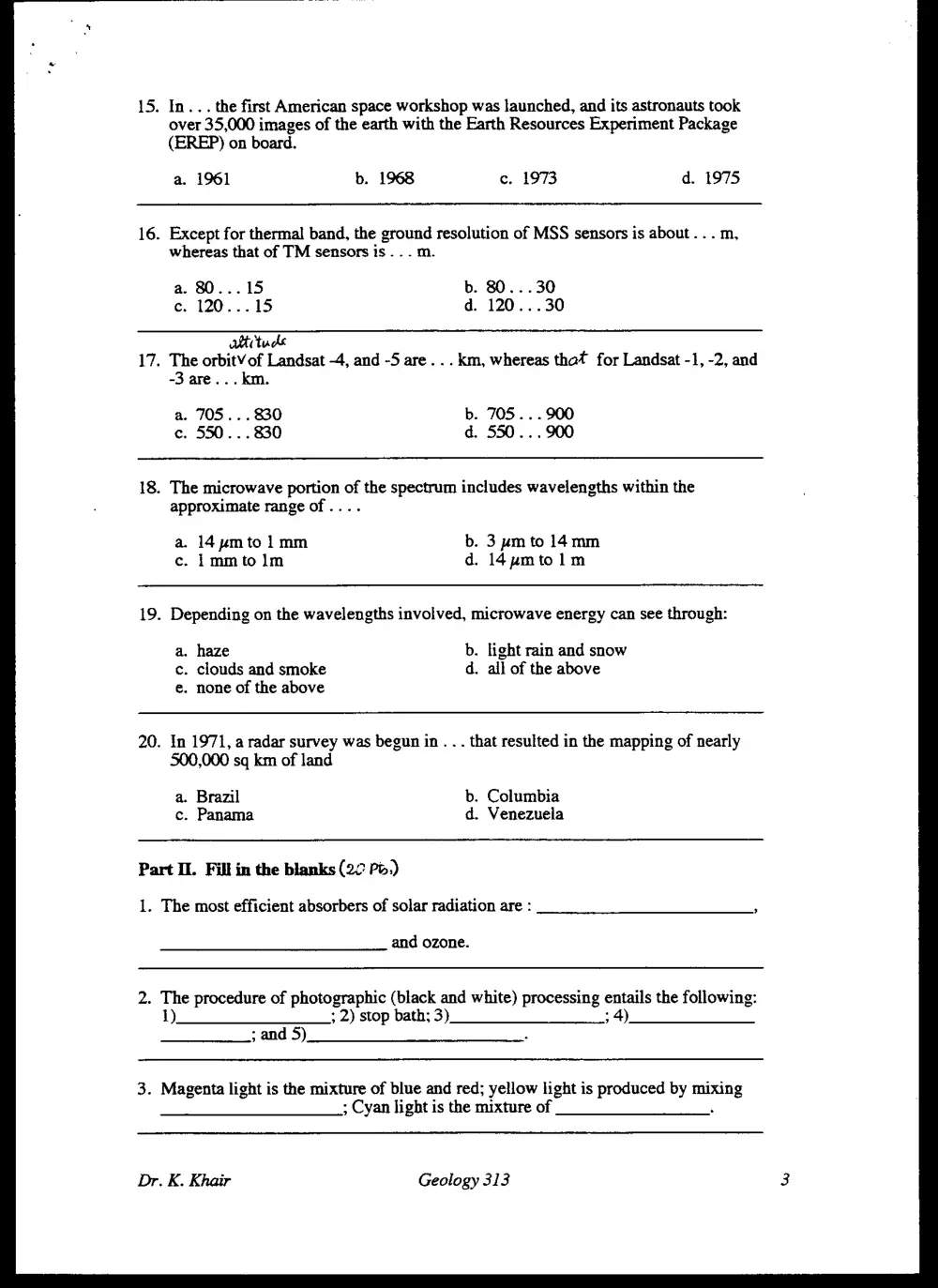
15. In... the first American space workshop was launched, and its astronauts took
over 35,000 images of the earth with the Earth Resources Experiment Package
(EREP) on board.
a. 1961 b. 1968 c. 1973 d. 1975
16. Except for thermal band, the ground resolution of MSS sensors is about . . . m,
whereas that of TM sensors is . . . m
a. 80...15 b. 80...30
ce. 120...15 d. 120...30
atitads
17. The orbitV of Landsat -4, and -5 are... km, whereas that for Landsat -1, -2, and
-3 are... km.
a. 705... 830 b. 705... 900
c. 550... 830 d. 550... 900
18. The microwave portion of the spectrum includes wavelengths within the
approximate range of ....
a. 14ymto 1mm b. 3 pm to 14mm
c. 1mmtolm d. 14umtolm
19. Depending on the wavelengths involved, microwave energy can see through:
a. haze b. light rain and snow
c. clouds and smoke d. all of the above
e. none of the above
20. In 1971, a radar survey was begun in. . . that resulted in the mapping of nearly
500,000 sq km of land
a. Brazil b. Columbia
c. Panama d. Venezuela
Part II. Fill in the blanks (20 Po.)
1. The most efficient absorbers of solar radiation are : ,
and ozone.
2. The procedure of photographic (black and white) processing entails the following:
1). ; 2) stop bath; 3) 34)
; and 5) .
3. Magenta light is the mixture of blue and red; yellow light is produced by mixing
; Cyan light is the mixture of
Dr. K. Khair Geology 313
4A (CCD) isa
chip or a solid state sensor that detects electromagnetic energy.
5. The scale S of aerial photograph is computed as the ratio of
or for a vertical photograph
taken over flat terrain is computed as the ratio of
6. The ground resolution distance (GRD) is computed as
to the system resolution, for example
7. Most airphoto applications consider the following basic characteristic, or
variations of them: , , pattern, .
, Site and association.
8. The elimination key (airphoto interpretation) is arranged so that the interpretation
proceeds
9. The main advantages of scanning mirror stereoscope compared to lens and mirror
stereoscopes are:
10. The term land cover relates to
, for example
11. The term land use relates to
, for example
12. Orthophotos are prepared in instruments called
here the floating mark is a very small slit ina
13. Photographic systems require an onboard supply of film that must be
to the ground for processing, whereas MSS data may be
to ground.
14. (IFOV) is normally expressed
as the , with which incident energy is focused on the detector.
15. In "Radiation from Real Materials" a has an emissivity that
is less than | but is constant at all wavelength. However, if the emissivity of an
object varies with wavelength, the object is said to be a
Dr. K. Khair Geology 313
16. The types of sensors used on Landsat -1 to 6 missions are:
systems; (TM); and
(RBV) camera system; (MSS)
(ETM).
17. Data merging and GIS integration (Digital Image Processing) is used to combine
with
18. In contrast to spectral filters, spatial filters
19. Convolving an image involves the following procedures:
20. Spectral ratioing or ratio images are enhancements resulting from the division of
Part HI. Circle T = true or F = false
T F
1. According to wave theory the energy of a quantum (photons or
quanta) decreases with decreasing wavelength.
2. The dominant wavelength, or wavelength at which a blackbody radiation
curve reaches a maximum (Wien's displacement law) decreases with its
temperature increase
3. Water and vegetation might reflect nearly equally in visible wavelengths
yet these features are almost always separable in near-infrared wavelengths.
4. Photographic film can "see" and record over a wavelength range about
twice as broad as that of the human eye (0.3 to 0.9 ym versus 0.4 to 0.7 zm)
5. Antivignetting filters (used to improve the uniformity of exposure
throughout an image) are designed to be strongly absorbing in their circum-
ferential area and progressively transparent in their central area.
6. The shutter for a strip camera remains open continuously while the
picture is made, and the resulting imagery is distorted by any change in
aircraft orientation, speed, or altitude.
7. Although the current resolution of digital imaging systems is very good,
images are not as detailed as those imaged onto photographic film of
similar format.
Dr. K. Khair Geology 313
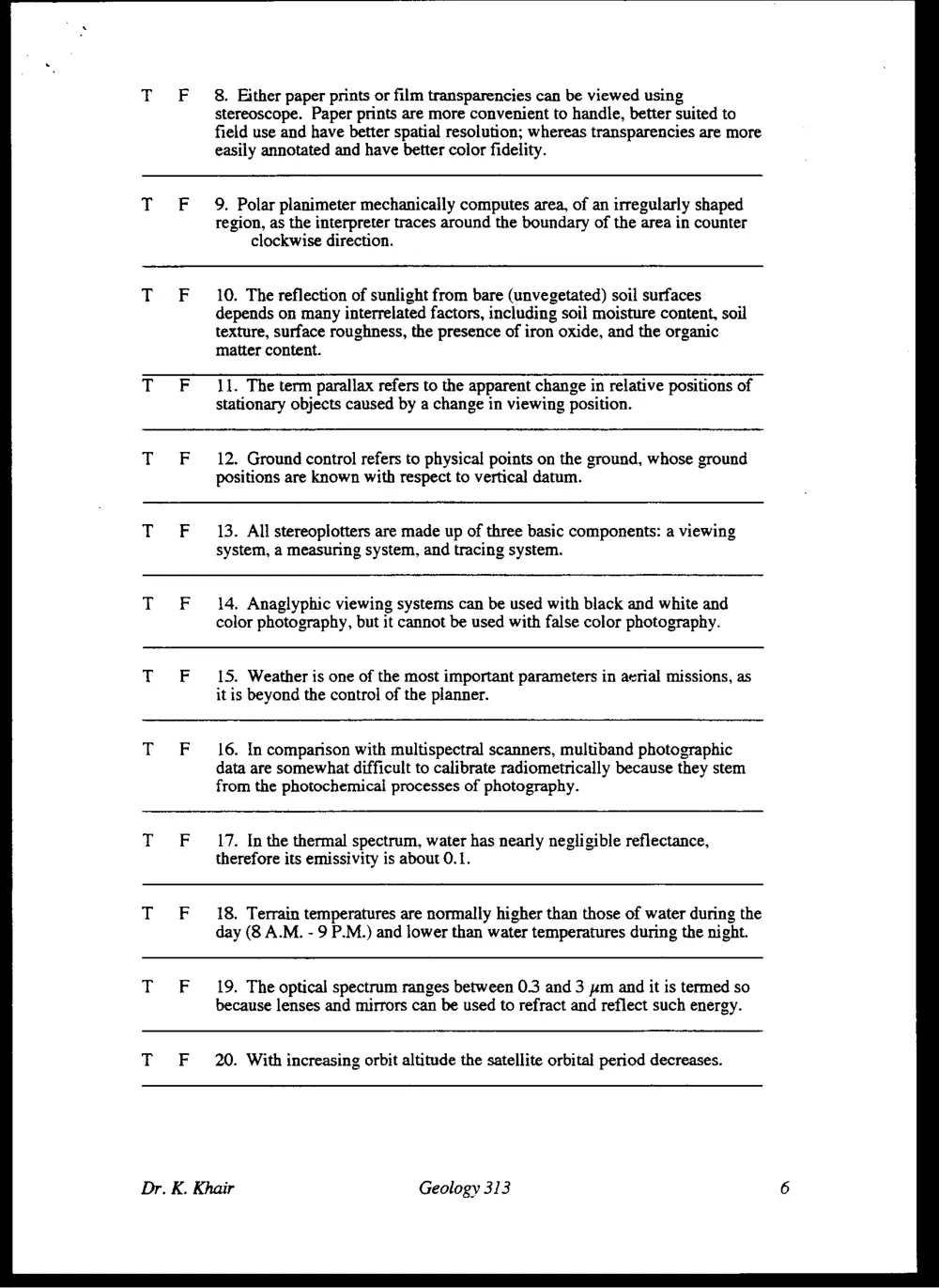
8. Either paper prints or film transparencies can be viewed using
stereoscope. Paper prints are more convenient to handle, better suited to
field use and have better spatial resolution; whereas transparencies are more
easily annotated and have better color fidelity.
9. Polar planimeter mechanically computes area, of an irregularly shaped
region, as the interpreter traces around the boundary of the area in counter
clockwise direction.
10. The reflection of sunlight from bare (unvegetated) soil surfaces
depends on many interrelated factors, including soil moisture content, soil
texture, surface roughness, the presence of iron oxide, and the organic
matter content.
11. The term parallax refers to the apparent change in relative positions of
stationary objects caused by a change in viewing position.
12. Ground control refers to physical points on the ground, whose ground
positions are known with respect to vertical datum.
13. All stereoplotters are made up of three basic components: a viewing
system, a measuring system, and tracing system.
14. Anaglyphic viewing systems can be used with black and white and
color photography, but it cannot be used with false color photography.
15. Weather is one of the most important parameters in aerial missions, as
it is beyond the control of the planner.
16. In comparison with multispectral scanners, multiband photographic
data are somewhat difficult to calibrate radiometrically because they stem
from the photochemical processes of photography.
17. In the thermal spectrum, water has nearly negligible reflectance,
therefore its emissivity is about 0.1.
18. Terrain temperatures are normally higher than those of water during the
day (8 A.M. - 9 P.M.) and lower than water temperatures during the night.
19. The optical spectrum ranges between 0.3 and 3 ym and it is termed so
because lenses and mirrors can be used to refract and reflect such energy.
20. With increasing orbit altitude the satellite orbital period decreases.
Geology 313
Part IV. Answer only eight of the following ten questions (40 pts.)
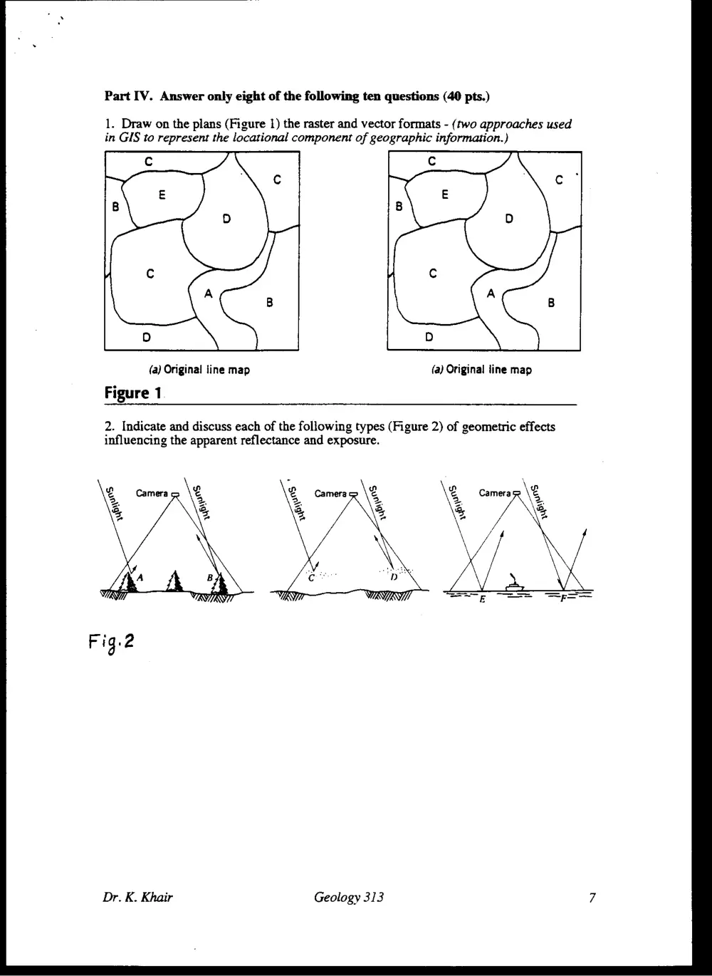
1. Draw on the plans (Figure 1) the raster and vector formats - (two approaches used
in GIS to represent the locational component of geographic information.)
{a) Original line map
Figure 1
(a) Original line map
2. Indicate and discuss each of the following types (Figure 2) of geometric effects
influencing the apparent reflectance and exposure.
Dr. K. Khair
Geology 313
5. Using Figure 5 explain floating mark principle.
Left eye Right eve
Photos viewed
in stereo
Stereomodel of terrain
Figure 5
6. Discuss the significance of atmospheric absorption and atmospheric windows on
the selection of the optimum spectral bands in remote sensing (Figure 6).
° s © Nv Oo a ° n s
é £ 82 8¢e ¢£ Se = 8 5}
—_—_—_—
tote TT a a |
80
®
- 3 60
=
€
2 40
&
5
20
of ee ee es
0 1 2 3 4 5 6 7 8 9 10 11 12 13,014 15
Wavelength (um)
Figure 6
Dr. K. Khair Geology 313 9
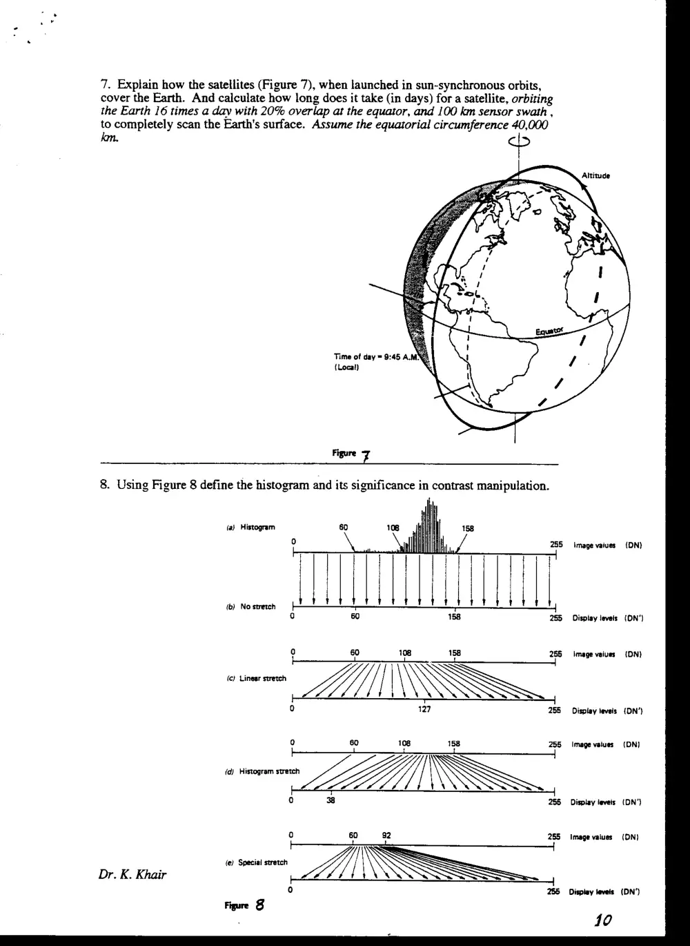
7. Explain how the satellites (Figure 7), when launched in sun-synchronous orbits,
cover the Earth. And calculate how long does it take (in days) for a satellite, orbiting
the Earth 16 times a day with 20% overlap at the equator, and 100 km sensor swath ,
to completely scan the Earth's surface. Assume the equatorial a. 40,000
Time of day = 9:45 A.MN&
{Locat) \
Figure rs
8. Using Figure 8 define the histogram and its significance in contrast manipulation.
Dr. K. Khair
—~ Zs -_
iM
oa
+
285
Figure 8
Image vaiues
Dispiay leveis
Image vaiues
Dispiay levels
Image vaiues
Display levels
Image values
Dispiay levels
{DN}
(ON*)
{DN}
{DN’}
(DN)
{DN')
(ON)
(DN’)