
GEOL 313 Final, Spring 2000
American University of Beirut · Photogeology · 7 pages


More GEOL 313 files
Show the text of this final exam
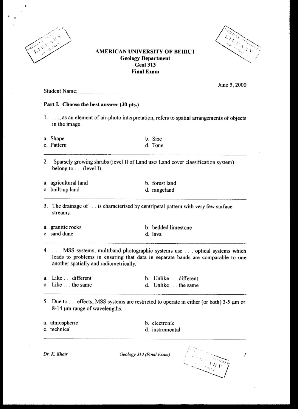
AMERICAN UNIVERSITY OF BEIRUT
Geology Department
Geol 313
Final Exam
June 5, 2000
Student Name:
Part I. Choose the best answer (30 pts.)
1, ..., as an element of air-photo interpretation, refers to spatial arrangements of objects
in the image.
a. Shape b. Size
c. Pattern d. Tone
2. Sparsely growing shrubs (level I] of Land use/ Land cover classification system)
belong to. . . (level I).
a. agricultural land b. forest land
c. built-up land d. rangeland
3. The drainage of. . . is characterised by centripetal pattern with very few surface
streams.
a. granitic rocks b. bedded limestone
c. sand dune d. lava
4. ... MSS systems, multiband photographic systems use . . . optical systems which
leads to problems in ensuring that data in separate bands are comparable to one
another spatially and radiometrically.
a. Like... different b. Unlike... different
c. Like... the same d. Unlike... the same
5. Dueto... effects, MSS systems are restricted to operate in either (or both) 3-5 um or
8-14 «um range of wavelengths.
a. atmospheric b. electronic
c. technical d. instrumental
Dr. K. Khair Geology 313 (Final Exam)
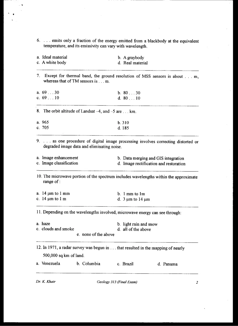
6. ... emits only a fraction of the energy emitted from a blackbody at the equivalent
temperature, and its emissivity can vary with wavelength.
a. Ideal material b. A graybody
c. A white body d. Real material
7. Except for thermal band, the ground resolution of MSS sensors is about . . . m,
whereas that of TM sensors is... m.
a, 69...30 b. 80... 30
c. 69...10 d. 80...10
8. The orbit altitude of Landsat —4, and —5 are... km.
a. 965 b. 310
c. 705 d. 185
9. ... as one procedure of digital image processing involves correcting distorted or
degraded image data and eliminating noise.
a. Image enhancement b. Data merging and GIS integration
c. Image classification d. Image rectification and restoration
10. The microwave portion of the spectrum includes wavelengths within the approximate
tange of :
a. 14m to 1mm b. 1mm to Im
c. 14umtolm d. 3umto 14 pm
11. Depending on the wavelengths involved, microwave energy can see through:
a. haze b. light rain and snow
c. clouds and smoke d. all of the above
e. none of the above
12. In 1971, a radar survey was begun in . . . that resulted in the mapping of nearly
500,000 sq km of land.
a. Venezuela b. Columbia c. Brazil d. Panama
Dr. K. Khair Geology 313 (Final Exam) 2
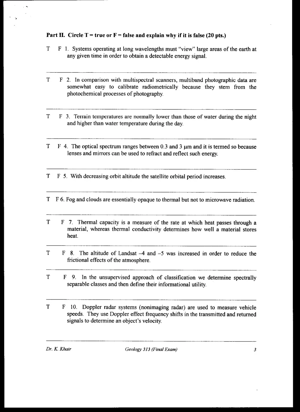
Part I. Circle T = true or F = false and explain why if it is false (20 pts.)
TF 1. Systems operating at long wavelengths must “view” large areas of the earth at
any given time in order to obtain a detectable energy signal.
TF 2. In comparison with multispectral scanners, multiband photographic data are
somewhat easy to calibrate radiometrically because they stem from the
photochemical processes of photography.
TF 3. Terrain temperatures are normally lower than those of water during the night
and higher than water temperature during the day.
TF 4. The optical spectrum ranges between 0.3 and 3 ym and it is termed so because
lenses and mirrors can be used to refract and reflect such energy.
TF 5. With decreasing orbit altitude the satellite orbital period increases.
TF 6. Fog and clouds are essentially opaque to thermal but not to microwave radiation.
T F 7. Thermal capacity is a measure of the rate at which heat passes through a
material, whereas thermal conductivity determines how well a material stores
heat.
T F 8. The altitude of Landsat -4 and —5 was increased in order to reduce the
frictional effects of the atmosphere.
T F 9. In the unsupervised approach of classification we determine spectrally
separable classes and then define their informational utility.
T F 10. Doppler radar systems (nonimaging radar) are used to measure vehicle
speeds. They use Doppler effect frequency shifts in the transmitted and returned
signals to determine an object’s velocity.
Dr. K. Khair Geology 313 (Final Exam) 3
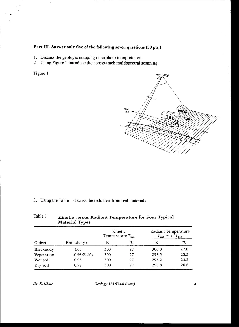
Part III. Answer only five of the following seven questions (50 pts.)
1. Discuss the geologic mapping in airphoto interpretation.
2. Using Figure 1 introduce the across-track multispectral scanning.
Figure 1
3. Using the Table 1 discuss the radiation from real materials.
Table 1 Kinetic versus Radiant Temperature for Four Typical
Material Types
Kinetic Radiant Temperature
Temperature Ty, Tra = € “Thin
Object Emissivity € K °C K °C
Blackbody 1.00 300 27 300.0 27.0
Vegetation B98 O90 300 27 298.5 25.5
Wet soil 0.95 300 27 296.2 23.2
Drv soil 0.92 300 27 293.8 20.8
Dr. K. Khair Geology 313 (Final Exam) 4
4, Give an overview of the Landsat Satellite Program and indicate the four types of
sensors that have been included in these missions.
Dr. K. Khair Geology 313 (Final Exam) 5
5. Using schemes describe the convolution and edge enhancement of spatial feature
manipulation (Image Enhancement).
6. Discuss contrast manipulation including gray-level thresholding, level slicing, and
contrast stretching (use Figure 2).
Figure 2
Dr. K. Khair
(2) Histogram
5
= va
AEH
H 138 255
ae ZT INS SS,
0
—_
fb) No stretch
6
¢ 255
ZAI
as
255
mo 7] Mae
Geology 313 (Final Exam)
Image values (DN)
Display levels (ON'T
frmage values (ON
Display levels (DN'}
Image valves {DNI
Display tevels {DN‘)
Image values (ON)
Display levels (ON‘)
6
7, Introduce the spatial resolution of SLAR systems including range and azimuth
resolution, draw schemes.
GOOD LUCK
Dr. K. Khair Geology 313 (Final Exam)